Smart Farming

Precision Agriculture Intelligence

Visualize every field, every zone, every sensor on interactive farm maps. Monitor soil health, track crop conditions, fly AI drone surveys, and respond to weather and pest events — all from a single platform built for modern agriculture.

Smart farm field map with real-time sensor overlays, drone imagery, and crop health indicators

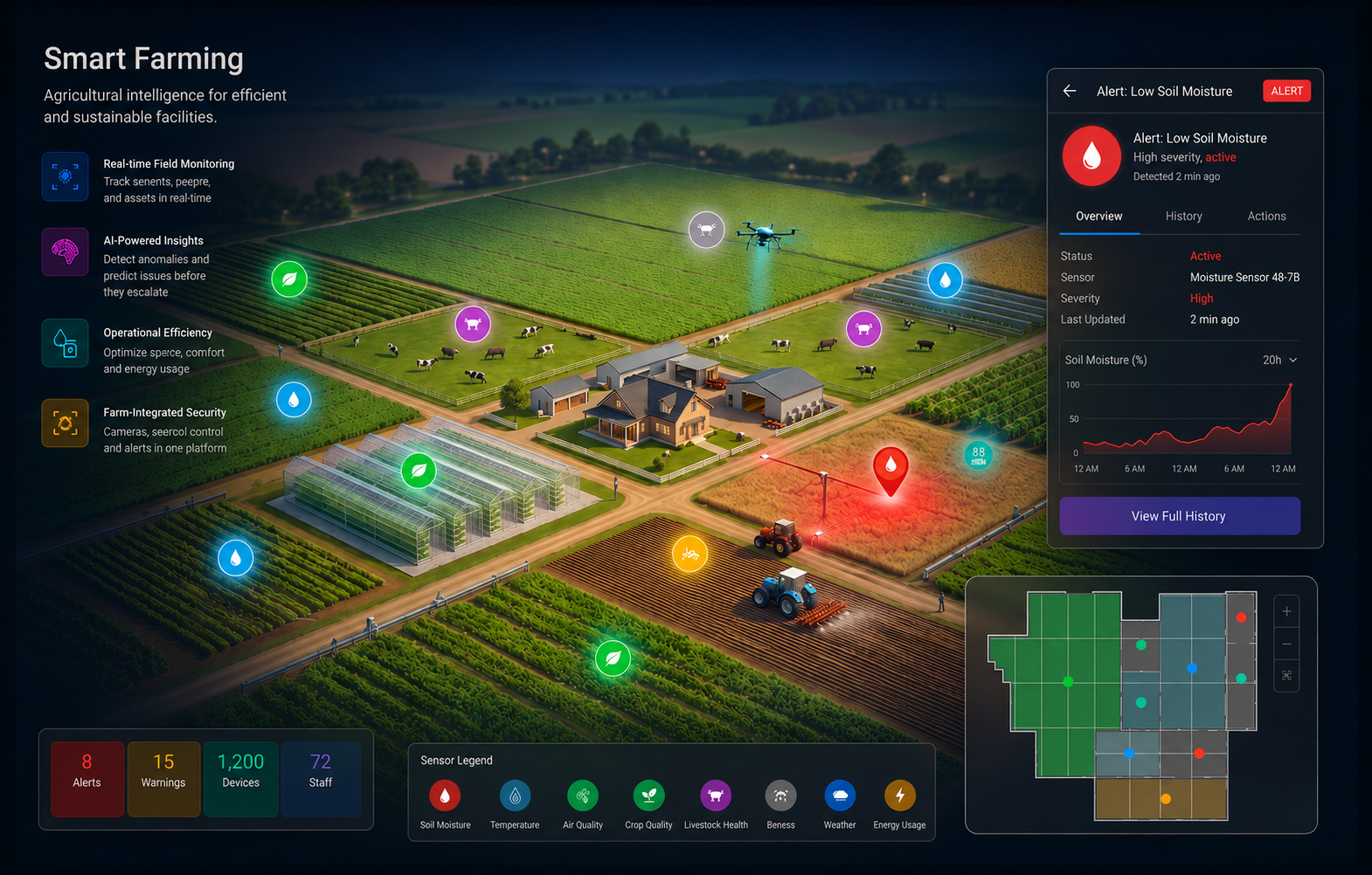
Farm Intelligence at Every Layer

From field map visualization to AI drone surveys — everything your team needs to manage crops proactively

Field Map Intelligence
Interactive farm maps with sensor layer overlays across every field, zone, and crop row. Click any location to see live soil readings, irrigation status, alert history, and trend data — anchored to your actual farm layout.
Real-Time Sensor Monitoring
Color-coded status across every sensor type. Instant visibility into soil moisture, temperature, nutrient levels, and environmental conditions — updated continuously as conditions change across the entire farm.
AI Drone Imaging
Satellite-like aerial imagery captured by AI-equipped drones on scheduled or on-demand flights. Detect crop stress, disease spread, pest damage, and irrigation gaps from above — and track field changes over time.
Crop Health Monitoring
Track vegetation indices (NDVI), canopy coverage, and growth patterns across fields. Predictive alerts surface emerging health issues before they affect yield, powered by AI image analysis and sensor fusion.

Every Sensor, One Platform

Connect all your farm sensors and see them mapped to the exact field and zone they monitor

Soil & Water
Soil moisture at multiple depths, nutrient levels (N, P, K), pH, salinity, and irrigation flow rates — per zone and per row.
Weather & Microclimate
On-farm weather stations tracking rainfall, temperature, humidity, wind speed, solar radiation, and evapotranspiration in real time.
Pest & Disease
AI camera traps detecting pest presence and density, disease early warning from leaf anomaly detection, and spray event logging.
Livestock & Storage
Animal health sensors, pasture occupancy monitoring, silo temperature and humidity, and cold chain compliance alerts.

Color-Coded Farm Situational Awareness

Each field and sensor zone on the map is color-coded by current status — so your team knows exactly where to focus

Critical
Immediate Action Required
  • Soil moisture critically low — North field
  • Frost risk detected — overnight forecast
  • Major pest outbreak confirmed by drone scan
  • Irrigation system failure in Zone 4
Warning
Attention Required
  • Soil pH drifting out of range — Block C
  • Canopy stress index rising — East quadrant
  • Nitrogen deficiency pattern detected
  • Rainfall deficit — 3rd consecutive dry day
Normal
All Systems Go
  • All soil sensors reporting optimal levels
  • Crop health indices within target range
  • Irrigation running on schedule
  • Weather within seasonal expectations

Built for Agronomists and Farm Operators

Two critical disciplines, one unified farm intelligence platform

Precision Irrigation & Agronomy
Data-driven field management from soil to canopy
  • Soil moisture maps driving variable-rate irrigation
  • Nutrient deficiency alerts by zone and field
  • Evapotranspiration-based watering schedules
  • Spray timing recommendations from weather data
  • Yield prediction from NDVI and growth models
  • Field-by-field crop rotation and input tracking
Drone Surveillance & Change Detection
Aerial intelligence that tracks your farm over time
  • Scheduled drone flights for weekly field scans
  • Side-by-side field comparison across flight dates
  • AI-detected anomaly zones flagged on farm map
  • Pest and disease spread pattern tracking
  • Canopy density and bare-ground change maps
  • On-demand flights triggered by sensor alerts

Measurable Results

Real impact from teams using Gostly to manage their farms and fields

30%
Water Savings
Sensor-driven irrigation eliminates overwatering and irrigates only where and when soil needs it.

Average water use reduction

Faster Detection
Spot crop stress, pest activity, and disease spread days earlier with AI drone imagery and sensor fusion.

Earlier issue detection vs. manual scouting

100%
Full Coverage
Every field, every zone, every sensor visible on one interactive map — always current.

Farm visibility across all fields

20%
Yield Protection
Predictive alerts and proactive interventions driven by real data protect harvest outcomes.

Average yield loss reduction

Integrates with Your Farm Systems

Connect with existing irrigation controllers, weather networks, drone platforms, and ag management software via standard protocols. Pre-built connectors for the most common precision agriculture tools.

DJI Agras DronesJohn Deere OperationsClimate FieldViewDavis WeatherLindsay IrrigationMQTT / LoRaWANTrimble Ag

Ready to Bring Your Farm Online?

Join agronomists and farm operators using Gostly to gain complete field-level intelligence across every crop, every sensor, and every drone flight